🌊 Core Foundation: The Indus River System
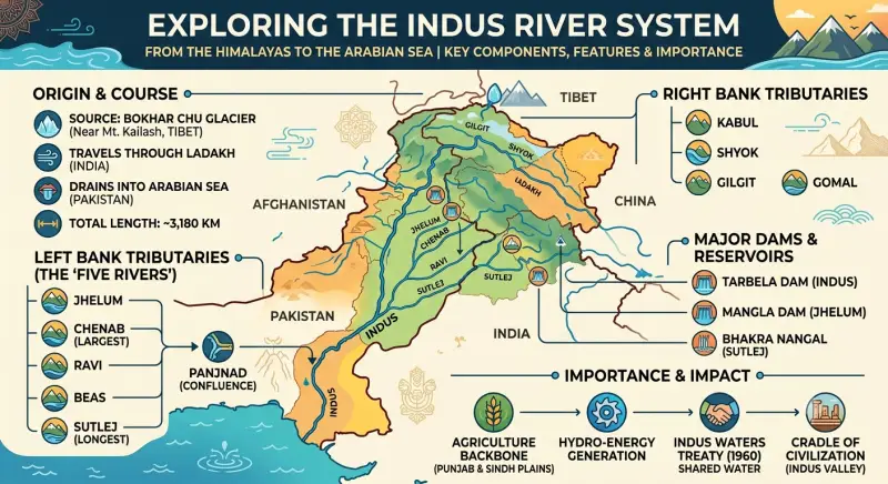
The Indus (Sindhu) is one of the largest river basins in the world, originating from the Bokhar Chu glacier near Mansarovar lake in the Tibetan region. It acts as a crucial lifeline and is the westernmost Himalayan river in India.
11,65,000 sq km
Total Basin Area
2880 km
Total Length
1114 km
Length in India
🚀 Tributaries & River Management
The Indus receives water from numerous tributaries before discharging into the Arabian Sea. The water sharing is governed by international agreements.
Key Tributaries
- Left Bank: Suru, Dras, Jhelum, Chenab, Ravi, Beas, Satluj
- Right Bank: Khurram, Shyok, Gomal, Gilgit, Sangar, Viboa, Tochi
- Panjnad: Meeting of 5 Punjab rivers above Mithankot
Indus Water Treaty (1960)
- India manages eastern rivers: Beas, Ravi, Satluj
- India can use 20% of total carried water
- Water used for irrigation, storage, and electricity in PB, HR, RJ
- Managed by Permanent Indus Commission
⚖️ Panch Doab (The Five Doabs)
The fertile land areas between two rivers are known as Doabs.
- 1. Bist Doab: Between Beas and Satlej
- 2. Bari Doab: Between Beas and Ravi
- 3. Rachana Doab: Between Ravi and Chenab
- 4. Chaj Doab: Between Chenab and Jhelum
- 5. Sindh Sagar Doab: Between Jhelum and Indus
Source Information: Geography of India - The Indus River System