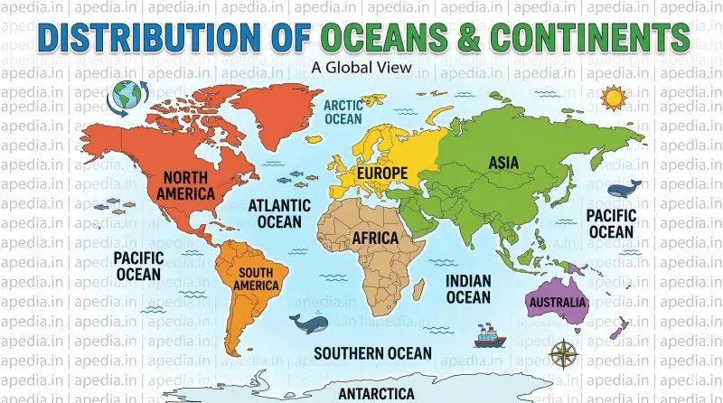
🌍 Distribution of Oceans and Continents
🗺️ Module 1: Continental Drift Theory
The positions of the continents and oceans have not remained static throughout Earth's history[cite: 4768]. In 1912, a German meteorologist named Alfred Wegener proposed the "Continental Drift Theory"[cite: 4778, 4779]. He suggested that all continents were once joined together in a single massive supercontinent called Pangaea (meaning "all earth"), surrounded by a mega-ocean called Panthalassa (meaning "all water")[cite: 4780, 4781]. Around 200 million years ago, Pangaea began splitting into two large masses: Laurasia in the north and Gondwanaland in the south, which later broke apart to form today's continents[cite: 4782, 4783, 4784].
Evidence Supporting Continental Drift
- Jig-Saw Fit: The coastlines of South America and Africa have a remarkable and unmistakable match[cite: 4787].
- Rocks of Same Age: Ancient rock belts (2,000 million years old) on the coast of Brazil perfectly match those in western Africa[cite: 4794].
- Tillite: Sedimentary rocks formed from glacial deposits (the Gondwana system) in India have identical counterparts in Africa, Madagascar, Antarctica, and Australia, indicating shared histories[cite: 4797, 4799, 4801].
- Placer Deposits: Rich gold deposits are found on the Ghana coast, but the source rock is uniquely located across the ocean in Brazil[cite: 4805, 4806].
- Fossil Distribution: Fossils of the Mesosaurus, a small freshwater reptile, are found only in South Africa and Brazil, which are now separated by 4,800 km of ocean[cite: 4810, 4811, 4812].
📝 Concept Check 1
1. Who proposed the Continental Drift Theory in 1912? [cite: 4778, 4779]
Alfred Wegener
2. What was the name of the massive mega-ocean surrounding Pangaea? [cite: 4781]
Panthalassa
3. What type of rock is formed from glacial deposits? [cite: 4797, 4798]
Tillite
4. Which two forces did Wegener suggest caused the drifting? [cite: 4815]
Pole-fleeing force and tidal force
🌊 Module 2: Sea Floor Spreading
Following World War II, detailed mapping of the ocean floor revealed that it is not a flat plain but features deep trenches and the longest mountain chains on Earth, known as Mid-Oceanic Ridges[cite: 4833, 4834, 4877]. Arthur Holmes had previously suggested in the 1930s that convectional currents operate in the mantle, driven by radioactive decay[cite: 4828, 4829].
In 1961, Harry Hess synthesized these post-drift discoveries to propose the "Sea Floor Spreading" hypothesis[cite: 4926]. He argued that constant volcanic eruptions at the crests of oceanic ridges cause the oceanic crust to rupture[cite: 4927]. New lava pushes into the crack, spreading the ocean floor horizontally on either side[cite: 4927, 4928]. The older crust eventually sinks down at oceanic trenches and gets consumed back into the mantle[cite: 4953].
🧩 Module 3: Plate Tectonics
In 1967, McKenzie, Parker, and Morgan independently formulated the unifying theory of Plate Tectonics[cite: 4958, 4959]. A tectonic plate is a massive, irregularly shaped slab of solid rock that makes up the lithosphere[cite: 4975]. Earth's lithosphere is fractured into seven major plates and several minor ones[cite: 4980].
Types of Plate Boundaries
- Divergent Boundaries: Plates pull away from each other, generating new crust. These are called spreading sites (e.g., Mid-Atlantic Ridge)[cite: 5046, 5047, 5048].
- Convergent Boundaries: Plates collide, and one plate dives under another, destroying crust in a subduction zone[cite: 5051, 5052].
- Transform Boundaries: Plates slide horizontally past each other, neither producing nor destroying crust[cite: 5057].
The Journey of the Indian Plate: India was once a large island separated from Asia by the Tethys Sea[cite: 5084, 5085]. It began its northward journey around 200 million years ago, eventually colliding with Asia 40-50 million years ago, which caused the rapid uplift of the Himalayas—a process still continuing today[cite: 5086, 5087, 5108].
📝 Concept Check 2
1. Who proposed the concept of Sea Floor Spreading? [cite: 4926]
Harry Hess
2. How many major tectonic plates is the Earth divided into? [cite: 4980]
Seven
3. What kind of boundary generates new crust? [cite: 5046]
Divergent Boundary
4. The collision of the Indian plate with Asia formed which mountains? [cite: 5087]
The Himalayas